GARMIN :
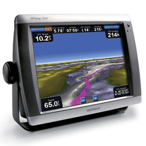
GPSMAP5012 12.1吋航海用觸控導航機
 |
| Hits 今天: 1 總計: 3821 |
 |
 參考評論 (0)
| 參考評論 (0)
|  評論這項產品 | 評論這項產品 |  產品
Q & A |
 以電子郵件傳送 |
列印 | 地圖更新 | GPS 系統軟體更新 | Mac OS 系統支援 以電子郵件傳送 |
列印 | 地圖更新 | GPS 系統軟體更新 | Mac OS 系統支援 |

|

|
|
產地 >
主機 : 台灣 .  | 附件 (電纜線, 文件, 包裝..) :
. 同主機產地
 |
|
Garmin 12.1 吋海上專用 GPS 圖台. 支援 NMEA 2000 網路, 內附有專用 GPS 接收機的安裝架, 可輕易連接 NMEA 2000 相容的深納, 雷達, 風向風速計, 電羅經, 魚探機, 油錶, 衛星氣象台, 海用無線電收發機, 自動駕駛系統, 引擎監視系統, 舵角監控. 等等設備. 觸控式操作, 可另購搖控器, 並可並聯多台 GPS 圖台 (NetWork) 具 VGA 輸出. |
| 供貨狀況 |
|
停止供貨中
|
|
特價:
NT$108,000.00
(含 5% 營業稅)
|
|
|
|
|
|
This flagship marine navigator is missing only one thing — buttons. The GPSMAP 5012 features an unprecedented touchscreen interface, along with a satellite-enhanced worldwide basemap and a massive 12" (31 cm) screen that makes navigation as easy as pointing your finger. By connecting to the Garmin Marine Network, you can add sonar, radar and weather. For even more advanced features, you can add the optional BlueChart® g2 Vision® card.
View Detailed Graphics and Video
The GPSMAP 5012 features a worldwide basemap with high-quality satellite images in place of more traditional maps. For even more detail, you can add maps easily with the SD™ card slot without having to connect to a computer. The 5012’s huge XGA screen displays graphics with crisp, video-quality resolution. To keep tabs on your engine room or other area of your boat, you also can connect a live video feed with the 5012's video input/output options.
Add Extras with BlueChart g2 Vision
With the optional BlueChart g2 Vision SD card, you can add a whole new dimension of exceptional features to your chartplotter..
•MarinerEye view and FishEye view provide you a 3-D perspective of map information, both above and below the waterline.
•High-resolution satellite images and aerial photographs help you orient yourself in unfamiliar areas.
•Auto Guidance technology searches through all relevant charts to create a route you actually can follow — one that avoids obstacles, shallow water, buoys and other obstructions.
Connect to the Garmin Marine Network
The 5012 connects easily to the high-speed Garmin Marine Network, so you can interface with additional MFDs and add remote sensors. Once connected, you can share information between the 5012 and other chartplotters on your boat. You also can add high-powered radar and sonar to your system.
|
實體與效能: |
| 裝置尺寸 (寬x高x深): |
13.0" x 9.5" x 4.7" (33.0 x 24.1 x 11.9 cm) |
| 螢幕尺寸 (寬x高): |
9.7" x 7.3", 12.1" diagonal (24.6 x 18.4 cm, 30.7 cm diagonal) |
| 螢幕解析度 (寬x高): |
1024 x 768 pixels |
| 螢幕類型: |
Touchscreen XGA display |
| 重量: |
9.5 lb (4.3 kg) |
| 電池: |
none |
| 電池壽命: |
none |
| 防水性: |
有 (IPX7) |
| 高感度接收器: |
有 |
| 天線: |
external |
| NMEA 輸入/輸出: |
NMEA 0183, NMEA 2000 |
地圖與記憶體: |
| 底圖: |
有 |
| 預先載入地圖: |
否 |
| 可新增地圖: |
有 |
| 內建記憶體: |
none (cannot load maps to internal memory) |
| 可接受資料卡: |
SD™ card slot (BlueChart g2 Vision cards sold separately) |
| 航點/喜愛點/位置: |
1,500 |
| 航線: |
20 |
| 航跡記錄: |
10,000 points; 20 saved tracks |
功能: |
| 與 Garmin 雷達相容: |
有 |
| 與 Garmin 聲納相容: |
有 |
| 與 Garmin Marine Network™ 相容: |
有 |
| 觸控式螢幕: |
有 |
| 支援 AIS (追蹤目標船隻位置): |
有 |
| 支援 DSC (從具有 DSC 功能的 VHF 無線電顯示定位資料): |
有 |
| 有聲鬧鐘: |
有 |
| 潮汐表: |
有 |
| 狩獵/捕魚日曆: |
否 |
| 日出日落/月出月落資訊: |
有 |
| 3D 地圖檢視: |
有 (需選購 BlueChart g2 Vision 海圖卡) |
| 自動引導: |
有 (需選購 BlueChart g2 Vision 海圖卡) |
| 與美加規的 XM WX 天氣與無線電訊號 相容: |
有 |
| 自動航線規劃 (道路轉彎逐一提示): |
否 |
| 語音提示 (例如,500 英呎後右轉): |
否 |
| 播報路名 (例如,500 英呎後在榆樹街右轉): |
否 |
| 耳機插孔/音效輸出: |
否 |
| 音訊/視訊輸入/輸出: |
有 |
| 可攜式: |
否 |
| 適合汽車/機車使用: |
否 |
| 其他: |
Interface Inputs/Outputs: 4 NMEA 0183 inputs, 2 NMEA 0183 outputs; 2 video inputs for onboard cameras, 1 PC monitor video output |
|
|
|
|
|
| 特價: |
NT$108,000.00
(含 5% 營業稅)
|
|
|
| 供貨狀況 |
|
停止供貨中
|
|
|
|

